 |
Lone Star Trail |
|
Lone Star Trail |
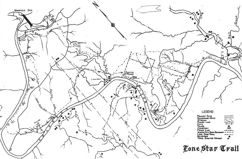 Click HERE for large route map of Lone Star Trail Lone Star Trail was a trail that went from Camp Tom Wooten along Lake Austin all the way West to Mansfield Dam at Lake Travis of the Colorado River. When the trail was completed, they had two campsites, each with a shelter built along the trail, for groups to set up camp and be sheltered from the weather for cooking. The Lone Star Trail was dedicated to Explorer Scouting, through efforts of Lone Star Post 18. The trail was made possible by friends of Scouting, who had contributed generously in material, and allowing Scouts and Explorers to travel through public and private property. The rules of conduct were as follows: 1.
Stick to the trail, and use only selected sites,
granted by property owners, for over-night stops.
E. W.
(Bill) Cartwright was Advisor, Lone Star Trail,
for Explorers.
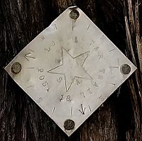
A typical aluminum Lone Star Trail marker. Photo provided by Steve Mulanax.
.
The
first treks from Camp Tom Wooten included donkeys
that carried the food and cook gear. The
Scouts hiked the trail all the way to Mansfield
Dam and back again. They took two days to
hike up to the dam and two days to hike
back. They camped at two established
campsites along the trail.
Each
night they would stop at one of the two Lone Star
Trail kitchen shelters, establish camp, and
prepared supper. The next morning, after
breakfast, they would break camp and continued on
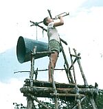
the trail. Shown to your right is the
shelter at Lake Travis near the Mansfield
Dam. Note the pith helmet and surplus sailor
cap that were popular at the time. The one
seated with the dark T-shirt looks like Don
Lee. He made several trips to Lake Travis
with the donkeys and Scouts. This picture
was taken sometime between 1953 and 1955.
This is
the other Lone Star Trail kitchen and
campsite. This one was located on the L.
East Ranch between Camp Tom Wooten and Lake
Travis. This area later became the Austin
City Park and even later the Lake Austin
Metropolitan Park. Later, the program became known as the Pack and Paddle Program whereas one group hiked to the dam while another group paddled up the Colorado River from camp to the dam. Their food was trucked to them from camp. They met at the shelter near the dam and the next morning, the group that hiked, paddled the canoes back to camp whereas those that canoed up the river hiked back down the Lone Star Trail to Camp Tom Wooten. Phil
Pegues: relates "I did the Pack and Paddle
one year. We 'buried' an old trunk up on a
cliff side cave. A clay pot, sealed with old
wax, was buried in the sand of one campsite.
It is accidentally uncovered during some 'scuffle'
play. Inside was a map of the area with the
cave marked with an X. When the scouts went
into the cave and found the trunk, there was candy
inside. For the Trail scouts, the National
Guard dropped parachutes with candy while they
were hiking in the open. Do not believe
these were used as standard events after my
session. Do not know what happened to the
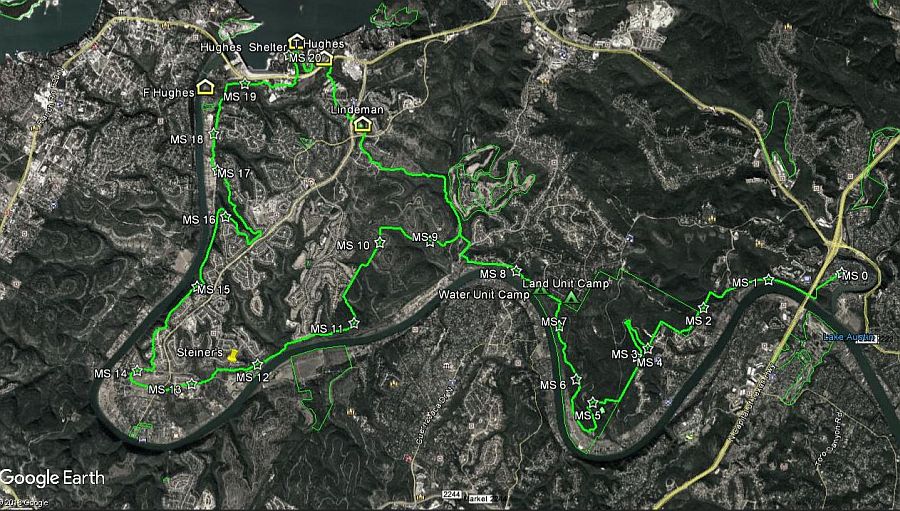
trunk." Georeferencing Map by
Steve Mulanax
|
 Should you use this map, you need to be aware of private property rights, trespassing, and being arrested, etc. Always check with the land owner before crossing their property. |
|
We want to thank Joe Lee for finding these photos of the Lone Star Trail. He is the younger brother of Leo Lee. And, we want to thank Te Starr for the photos of the Lone Star Trail marker being installed, and to Steve Mulanax for the photo of the aluminum marker and the above georeferencing map. According to a story in The Austin Statesman, Harper, Ken. (1950, Apr 18). "Biologist says Highland Lakes Fishing Best in Texas, Year in and Year Out," it puts the opening date for the Lone Star Trail at Sunday April 23, 1950. The project was endorsed by the Lake Travis Improvement Association at their monthly meeting, according to the story. | Home | Aquatics | Program | Facilities | Other Photos | Other Photos Yet
| Patches | Staff | Promotion |
|